
Garmin GPSmap 65s Europe
Garmin GPSmap 65s Europe
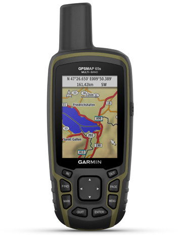
The Garmin GPSmap 65s Europe is a smart map-based GPS navigation system with a 2.6" display with classic push-button controls and multiband support for high accuracy activity recording. The navigation system enables multi-band reception of signals from multiple satellite networks, offering high positioning accuracy even in challenging terrain. Built-in sensors, including a barometric altimeter and a three-axis compass allow you to more accurately determine direction and altitude during your activities. With support for the web and the Garmin Explore™ mobile app, you can conveniently plan your adventures on the go and back up your data for future reference. You'll also enjoy the long battery life of up to 16 hours with GPS on, which you'll appreciate on day hikes and expeditions. The navigation also supports the TopoActive Europe app.

Key features of Garmin GPSmap 65s Europe GPS navigation
- Support for multiple GNSS systems for reliable navigation even in challenging terrain
- Geocaching Live and Garmin Explore™ app for easy planning and updates
- Digital 3-axis with tilt compensation
- Protection rating IPX7
- Cover glass material: chemically strengthened glass
- Battery life 16 hours
- With 16 MB memory
- Mini-USB, NMEA 0183 compatible
- Support for Bluetooth® and ANT+® wireless connectivity
Never get lost with Garmin GPSmap 65s Europe
Multiband signal reception and support for various satellite systems (GPS, GLONASS, Galileo, QZSS and IRNSS) ensures ideal positioning accuracy in challenging terrain where a standalone GPS would not be sufficient. Navigating in the field is made easier with ABC sensors - an altimeter providing altitude data, a barometer monitoring the weather and a three-axis electronic compass.

Plan, navigate, track
The Garmin GPSmap 65s Europe provides detailed road navigation and offers up to 3,000 map segments and support for 250 BirdsEye satellite imagery files for detailed terrain views. The charts include detailed hydrographic features such as coastlines of the seas, Rivers, lakes, wetlands and seasonal flows, show national parks, protected landscape area, nature reserves and points of interest including parks, campsites and viewpoints. Navigation allows you to store up to 5,000 waypoints, 200 passed routes and a route record with 10,000 waypoints, and supports up to 200 routes with a maximum of 250 points, or 50 points with automatic navigation. There are point-to-point navigation functions, area calculations, fishing times, sunrise and sunset information and moon phase. Navigation is also suitable for electronic geocaching and supports user maps (up to 500 tiles) and image viewing.

2.6-inch TFT display
The navigation system is equipped with a 2.6″ TFT transflective colour display with a screen size of 6.6 cm and dimensions of 3.6 × 5.5 cm, which ensures good readability in direct sunlight and in different lighting conditions. The display offers a resolution of 160 × 240 pixels and displays up to 65,000 colours for clear and detailed maps, routes and data fields during your activities. You can monitor incoming emails, text messages and alerts on the device display. Just pair the navigation with a compatible device (Android and iOS).

Geocaching with Garmin Explore™
Always keep your data up to date. Get automatic updates on Geocaching Live treasures, including descriptions, alerts and hints. Plan, check and sync your waypoints, routes and trails via the web and Garmin Explore*. You can even see the activities you have completed in the field. Free Garmin Explore™ mobile app lets you connect your navigation to your smartphone, Automatic software updates, cloud storage, trip planning, smart notifications and more. Plus, when you connect with the Garmin Explore™ app, you can get up-to-the-minute weather information so you know exactly what to expect on your adventure.
*In case of connection with a smartphone.

MicroSD slot and reliable battery
Thanks to the microSD card slot, you can increase the available memory from 16 GB up to 32 GB. For example, you can acquire additional TOPO maps for different regions or work with HuntView Plus maps, where you can find data on public and private land boundaries. The Navigation is powered by two AA batteries (NiMH or lithium batteries are recommended), which enable its long-term operation for up to 16 hours during all-day hikes and outdoor expeditions.


With TopoActive Europe and Garmin Connect™ on the go
TopoActive Europe maps provide automatic route calculation for convenient planning and navigation on your travels. The maps include data such as roads and routes, altitude, coastline, rivers, landmarks and other information. A voucher to download Topo Czech PRO is included in the package. Of course, it's compatible with the Garmin Connect™ mobile app, can receive smart notifications when connected to your phone, and can remotely control the VIRB® camera directly from the navigation.
Package contents:
GPSMAP 65s, USB cable, carabiner with grip, documentation
Specifications
Navigation type
Hardware and Software
Battery life and memory
Equipment and features
Maps
Languages
Dimensions
Weight
Color and finish
Package contents
| Code: | SPTgarm0032 |
| Warranty: | 24 months |
| Links: | Producer's Website: |
| Manufacturer information |
Garmin Würzburg GmbH, Leightonstraße 7, 97074 Würzburg, Německo, www.garmin.com, [email protected] 
|